
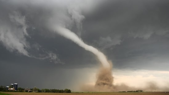
A tornado warning was sounded for South central Jefferson County and North central Oswego County in New York on Wednesday.
")
“Heads up for those south of Watertown. The National Weather Service in Buffalo has issued a * Tornado Warning for… South central Jefferson County in central New York… North central Oswego County in central New York… * Until 545 PM EDT. * At 507 PM EDT, a severe thunderstorm capable of producing a tornado was located near Sandy Island Beach State Park, moving northeast at 30 mph,” wrote Bill Kardas, Chief Meteorologist for NewsChannel 2.
“Flying debris will be dangerous to those caught without shelter. Mobile homes will be damaged or destroyed. Damage to roofs, windows, and vehicles will occur. Tree damage is likely. * Locations impacted include… Sandy Island Beach State Park, Pulaski, Adams, Selkirk Shores State Park, Sandy Creek, Lacona, Mannsville, Ellisburg, Montario Point, and Port Ontario. This includes Interstate 81 between exits 37 and 41,” he added.
The weather expert further said “TAKE COVER NOW! Move to a basement or an interior room on the lowest floor of a sturdy building. Avoid windows. If you are outdoors, in a mobile home, or in a vehicle, move to the closest substantial shelter and protect yourself from flying debris.” He also shared a map of the areas likely to be hit.
“This will head north of Rome and Utica,” he added. The National Weather Service warned of severe thunderstorms. “Severe Thunderstorm Warning continues for Syracuse NY, Fairmount NY and Baldwinsville NY until 5:45 PM EDT,” NWS wrote on X.
Meanwhile, visuals were shared showing dark clouds forming over Syracuse.
“Gorgeous view of the severe-warned line of thunderstorms moving into the Syracuse, NY area,” one person wrote.
Another added “Durhamville looking NE.”
(This is a developing story)