
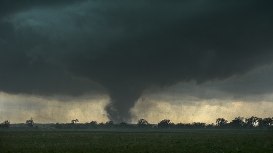
A dangerous tornado emergency was declared Wednesday night for parts of Mississippi as a large and destructive tornado moved across areas near Brookhaven toward Monticello and Silver Creek.
")
‘Life threatening situation’
The National Weather Service office in Jackson warned residents that the tornado posed a ‘life-threatening situation’, urging people to take cover immediately as the storm tracked east at around 35 mph.
Tornado emergency issued for Monticello and Silver Creek
At 8:04 PM CDT, meteorologists confirmed a ‘large and destructive tornado’ near Enterprise, close to Brookhaven. Officials warned that the tornado could bring catastrophic damage, including destroyed homes, businesses, vehicles, and deadly flying debris.
The storm was expected to move through or near several Mississippi communities through the evening, including:
East Lincoln around 8:10 PM
Sontag around 8:15 PM
Monticello and Wanilla around 8:20 PM
Silver Creek around 8:30 PM
Oma around 8:35 PM
New Hebron around 8:40 PM
The warning remains in effect until 9 PM CDT for parts of Lincoln, Lawrence, and Jefferson Davis counties.
Additional tornado activity reported across Mississippi
Meteorologist Payton Malone reported that two tornadoes were active in Mississippi Wednesday evening, including storms near Hattiesburg and Bude.
Earlier in the evening, just before 6 p.m., another tornado was confirmed between Lexie and Simmon, Mississippi.
At 7:45 PM, officials also reported a tornado south of Brookhaven.
Tornado warning expires for some areas
An earlier tornado warning covering areas including Tylertown, Lexie, and Mount Hermon has since expired. However, dangerous weather conditions continue across the region.
Tornado watch remains active
A Tornado Watch remains in effect until 11 PM for:
Tangipahoa Parish
Washington Parish
Pearl River County
Separate tornado warning issued in Greene County
Meanwhile, the National Weather Service office in Mobile issued another tornado warning for northeastern Greene County until 8:30 PM CDT.
At 8:16 PM, radar indicated rotation near Leakesville, with the storm capable of producing a tornado and golf ball-sized hail while moving east at 40 mph.
Forecasters warned residents not to wait to see or hear the tornado because nighttime tornadoes are especially difficult to detect.