


Patna
oi-Oneindia Staff

Bihar is running a 31 per cent rainfall deficit this monsoon (yes, you read it correctly). On 5th September the Ganga at Patna went higher than it has ever been recorded. Both of those sentences are true, and together they are the whole story.
At ten in the morning on Saturday, 5 September 2026, the Ganga at Gandhi Ghat in Patna touched 50.53 metres. The Water Resources Department noted that the river had risen ten centimetres in four hours and was now one centimetre above the highest flood level ever measured there – 50.52 metres, set on 21 August 2016. By dawn the next day it stood at 50.57 metres.
Bihar faced a 31% monsoon rainfall deficit in 2026, yet the Ganga river in Patna reached a record 50.53 meters on September 5, impacting 48.70 lakh people across 15 districts, attributed to narrowed riverbeds from decades of embankment policy.

Meanwhile, the Meteorological Centre at Patna was reporting that Bihar had received 592 mm of rain this season against a normal of 858 mm. A shortfall of 31 per cent. June had closed 46 per cent short. Through July and early August the deficit ran above 40 per cent. The IMD had forecast a below-normal monsoon for Bihar back in April, and the forecast held.
So: a state short of a third of its rain, and a capital city whose river has never been higher.
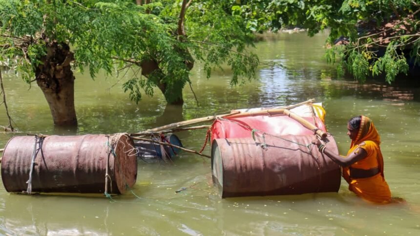
By 13th September 2026 the Disaster Management Department counted 48.70 lakh people affected across 575 gram panchayats, 88 blocks and 15 districts – Patna, Bhojpur, Saran, Vaishali, Bhagalpur, Begusarai, Buxar, Samastipur, Munger, Katihar, Lakhisarai, Khagaria, Purnia, Madhepura and Araria. At least ten people had drowned: five in Danapur and Maner in Patna district, and five more at Koili Khutaha in Bhagalpur, four of them from a single family.
There was no national bulletin. By Monday i.e. 13th September 2026 evening the story was gone.
Stage, not flow
Before the obvious objection: yes, the water that drowned Patna did not fall on Bihar. It fell in Nepal, in eastern Uttar Pradesh, in Jharkhand. Bihar’s own deficit does not by itself prove anything about the Ganga’s discharge.
But note carefully what was broken on 5th September. Not a discharge record. A stage record, a water-level record. The gauge at Gandhi Ghat measures how high the river stands, not how much is passing. And the height a given volume of water reaches depends entirely on the shape of the channel carrying it.
That channel has been getting shallower for seventy years, and we did it on purpose.
In 1954 Bihar adopted embankments as flood policy. It then had roughly 160 kilometres of them, and about 25 lakh hectares classified flood-prone. Today the Water Resources Department reports some 3,790 kilometres of embankment on thirteen rivers – and the flood-prone area stands at 68.80 lakh hectares, 73 per cent of the state’s land. A Central Water Commission assessment in 2016 put it at 3,731 kilometres and 72.95 lakh hectares. The direction is not in dispute: twenty-three times the wall, two and a half times the vulnerable land.
Dinesh Kumar Mishra of the Barh Mukti Abhiyan has spent forty years explaining why. A Himalayan river carries a colossal sediment load – the Kosi alone drops something on the order of 90 to 120 million cubic metres a year. Left alone, it spreads that silt thinly across a wide floodplain, which is why the Gangetic plain feeds us. Squeezed between two walls, it drops the same silt into a narrow trench. The bed rises. The water rises with it. The engineer raises the embankment. The bed rises again. Eventually the river runs above the fields it is meant to protect, held there by a mound of earth, and the only question left is where the earth gives way.
This September it gave way at Trilokchak in Saran, where twenty metres of the Mahi embankment collapsed, and again at Dariyapur; at Brahmottar in Gopalpur block, Bhagalpur, held only by an overnight effort of departmental engineers and villagers; and at three other points in Bhagalpur. In August 2008 it gave way at Kusaha inside Nepal, and the Kosi simply left its channel and went somewhere else, displacing upwards of thirty lakh people.
And we are still building. Detailed project reports are being finalised for new barrages on the Gandak at Areraj, the Masan in West Champaran, the Bagmati at Dheng, the Kamala at Jainagar, the Kosi at Dakmara and the Mahananda at Taiyabpur. Not one comes with a published projection of what it will do to bed levels upstream over the next thirty years.
The people inside the wall
There exists a category of Indian citizen almost never discussed: the one who lives on the river side of the embankment.
When the Kosi walls went up, villages were left inside them. Mishra’s fieldwork, using the 2001 Census, counted about 380 such villages – 162 in Supaul, 134 in Saharsa, 73 in Madhubani, nine in Darbhanga – with a population near 9.87 lakh. Thirty-four more lie inside the embankments on the Nepal side. These people were not moved, not compensated on any principle anyone can state, not rehabilitated. They live in the riverbed by law and design, and the bed rises under their houses every year.
They are the extreme version of a much wider condition. Ninety per cent of Bihar’s flood-prone area is in the north; roughly three-quarters of north Bihar lives with recurring risk. This is also the part of India that exports labour. Submerging three lakh hectares of cropland for weeks every year is among the most efficient migration machines ever built. The men go to Delhi, Surat, Punjab, Mumbai. The women stay and carry the entire household without a land record, a tenancy paper or a claim in their own name.
“Lakhs displaced” is therefore the wrong phrase. Displacement has a beginning and an end. This is a permanent condition with acute episodes.
Seven thousand rupees
Bihar’s relief machinery is not incompetent. In mid-September it was running over 1,200 community kitchens, some 1,800 boats, 27 SDRF and 10 NDRF teams, and had distributed around 3.5 lakh polythene sheets. The grihati anudan is ₹7,000 per affected family, raised from ₹6,000, paid straight into bank accounts – about ₹680 crore of it in 2025-26.
Now two comparisons
Forty-eight lakh people affected; fewer than fifteen relief camps, sheltering roughly 12,000. One person in four hundred. The state is not concealing this. It is operating on an unstated assumption – that a flood-hit family in Bihar will shelter itself on an embankment or a neighbour’s roof and needs a polythene sheet, not a bed. That assumption has never been debated or defended. It is policy by default.
The second is harder. In December 2025, Megh Pyne Abhiyan published a household-level loss assessment of 2,290 families across seven north Bihar districts hit by the 2024 floods. Total loss: ₹126.3 crore. Average per household: ₹5.51 lakh. Median: ₹2.11 lakh. Against a median loss of ₹2.11 lakh, the state’s grant is ₹7,000 – a little over three per cent.
No state budget can close that gap, and I am not pretending otherwise. The scandal is elsewhere. Bihar has a precise, audited, DBT-verified record of what it gave, and no system whatever for recording what was destroyed. Each year it sends Delhi a memorandum – ₹3,638 crore in 2024, about ₹3,600 crore in 2025 – built largely from departmental infrastructure estimates. The household ledger, when it exists at all, is kept by a charitable trust. A state that does not measure the damage can never be shown to have under-compensated. That is not an oversight. It is the most useful feature of the present arrangement.
The law nobody has used
Here is where I think the conversation should begin rather than end.
The Disaster Management Act, 2005 was substantially rewritten by the Disaster Management (Amendment) Act, 2025, Act 10 of 2025. Almost nothing was written about it, and it matters a great deal.
Section 9 of the amending Act omitted Sections 12 and 13 of the principal Act. Section 12 was the provision requiring the NDMA to recommend guidelines for minimum standards of relief: shelter, food, drinking water, medical cover and sanitation in camps; special provision for widows and orphans; ex gratia for death; assistance for damaged homes and lost livelihoods. Section 13 allowed relief in loan repayment. Section 19, the State mirror of Section 12, went too. And Section 61, which bars discrimination in relief, had the words “compensation and” struck out.
But the minimum-standards content was not abolished – it was relocated, and the relocation cuts both ways. It now sits as clause (w) in the NDMA’s list of functions under Section 6(2). A duty buried in a twenty-three-item list is harder to enforce by writ than a standalone section. Against that, the new Section 18(2)(o) obliges every State Authority to lay down relief standards for its State, with an express proviso that they shall in no case be less than the national minimum. That is arguably a stronger handle than the old Section 19 ever was: a duty, addressed to the State, with a statutory floor built in.
So far as I can establish, the Bihar State Disaster Management Authority has notified nothing under it. That is a justiciable omission.
Two further provisions have simply never been touched. Section 6(2)(u) requires the NDMA to conduct a post-disaster audit of a State’s preparedness and response “in the aftermath of severe disaster”. If a record river stage in a state capital, embankment failures in two districts and 48 lakh affected people do not trigger it, nothing will. Section 41A permits a State to constitute an Urban Disaster Management Authority for its capital and every Municipal Corporation city – which is precisely Patna’s annual problem, whether the water comes from the drains as in 2019 or the river as now.
The courts have not been silent either. In Swaraj Abhiyan (I) v. Union of India (W.P. (C) No. 857 of 2015, 11 May 2016), Lordships Lokur and Ramana JJ. dealt with States – Bihar among them – “hesitant to even acknowledge, let alone address” a disaster, and held that fiscal constraint is no answer to a statutory relief obligation. The reasoning travels from drought to flood without alteration.
And there is an irony sitting in the Supreme Court’s own file. The Court has been monitoring encroachment on the Ganga floodplain at Patna for three years. In March 2026 it recorded that of 213 encroachments identified between Digha Ghat and Nauzar Ghat, only 58 had gone. In July 2026 it gave the State six weeks to clear everything between Nauzar Ghat and Nurpur Ghat, overriding contrary interim orders below. Six weeks from late July expired in early September – the week the river came and cleared the floodplain itself.
Decades of Refusal
Underneath all of it lies a fifty-one-year refusal. The Central Water Commission circulated a Model Bill for Flood Plain Zoning in 1975. Manipur, Rajasthan, Uttarakhand and the erstwhile State of Jammu & Kashmir legislated; none has finished demarcation. Bihar, Uttar Pradesh, Assam, West Bengal and Odisha – between them most of India’s flood burden – have not. Bihar’s position on record is that such a law is neither practicable nor implementable. The Union is now moving to make enactment a condition of access to money under the Flood Management and Border Areas Programme. Better to legislate than to be made to.
Across the border, honestly
Every article on Bihar’s floods reaches the Sapta Kosi High Dam, and most oversell it.
A. N. Khosla’s commission investigated the Kosi in 1946. A Joint Project Office was set up in Nepal in August 2004 to prepare a detailed project report; twenty-two years later there is none. The 2022 Joint Committee on Water Resources agreed to advance the project “through further studies”. The Kosi and Gandak committee met in Kathmandu in late April 2026 and agreed on clearing canal encroachments, erosion control at Birpur, moving electric poles and sharing rainfall data – sensible housekeeping, not flood control. The next full JCWR round, the first in four years, was scheduled for the first week of September 2026. That is, for the week the Ganga broke its record.
Three honest caveats, though. A storage dam in a high seismic zone submerging large tracts of Nepali territory is a political question for Nepal before it is an engineering question for India, and seventy years of pretending otherwise have produced nothing. Every Himalayan reservoir has a finite sediment life: a dam buys decades, not permanence. And no dam does anything about 3,790 kilometres of embankment already standing.
The same discipline must apply to Farakka. Successive Bihar governments have blamed the barrage for Ganga siltation and demanded its removal. There is a real question there about the river’s depth downstream of Patna. But the CWC’s 2016 assessment concluded that even at worst the barrage’s backwater effect reaches about 42 kilometres upstream, and Patna is some 400 kilometres up. Bihar’s own Sanyal Committee, formed after the 2007 floods, did not name Farakka as the primary cause. A demand that cannot survive its own expert committee is a political position, not a technical one, and treating it as the answer has cost this state a decade of serious argument.
What should actually be done
Count the loss. Mandate a published, block-wise household loss assessment within sixty days of every recession. The methodology exists; a charitable trust has demonstrated it at scale. Until then, every argument about whether ₹7,000 is enough is unanswerable by design.
Make relief graded, and make it reach the landless. A flat per-family grant is elegant and arbitrary. Tier it against assessed loss, and build a channel that reaches sharecroppers, tenant cultivators and labourers, who today fall outside everything, because everything keys off a land record. Bihar’s flood economy runs on people who own nothing.
Notify State relief standards under Section 18(2)(o). The cheapest available step. Camp capacity per lakh affected, water and sanitation norms, medical cover, provision for pregnant women, the children, the elderly and the disabled – with the statutory floor that they cannot fall below the national minimum. Once notified, they are enforceable by writ. Today there is nothing to enforce.
Invoke Section 6(2)(u). The State, or any citizen, should move the NDMA for a statutory post-disaster audit of the 2026 Bihar floods, and for its publication. The provision has sat unused since 2025.
Legislate flood plain zoning – but draft it to survive. The objection that zoning is “unimplementable” is really an objection to eviction, and can be met. A workable Bihar Act would (a) demarcate and notify zones river by river on a published timetable; (b) bar new public investment – schools, sub-centres, panchayat buildings, housing schemes – in the highest-risk zone, which costs nobody their home; (c) require flood-zone disclosure in every sale deed and building permission, so risk is priced rather than hidden; and (d) protect and elevate existing settlements rather than criminalise them. A pure demolition statute is why fifty-one years have produced nothing.
Publish a sediment budget before every structure. No barrage, embankment extension or river link should get administrative approval without a published thirty-year bed-level projection, and an annual public silt audit after. That includes the Kosi-Mechi link, on which large sums are committed and independent scrutiny has been thin.
Spend on mitigation, not only relief. Section 48 of the Act contemplates a State Disaster Mitigation Fund. Capitalise Bihar’s and spend it on things that reduce next year’s loss: plinth raising, elevated homesteads, flood-proof grain and seed storage at panchayat level, elevation of schools and health centres in notified zones, and last-mile early warning linked to the Nepal-side gauges. Work by ICIMOD on these transboundary systems shows community warning can deliver several hours of usable lead time. Ten drownings is a last-mile failure, not a forecasting one.
Pilot parametric flood insurance. Conventional cover collapses here because verification at scale is impossible and claims take years. A parametric product pays automatically when a named gauge crosses a named level – no surveyor, no assessment, no discretion, no delay. The gauges exist and are read daily. For a state whose central complaint is that relief is slow and arbitrary, this converts a discretionary ₹7,000 into a contractual entitlement triggered by the river itself. It is the most under-examined idea available, and it deserves one district and one season.
The Politics
Bihar went to the polls in November 2025. In April 2026 Samrat Choudhary became Chief Minister. On 5th September he directed ministers and senior officials to camp in the affected districts and supervise relief – almost word for word what his predecessor directed in August 2025, and in 2024, and in most years before that.
I want to be precise, because the easy criticism is the wrong one. Every coalition this state has had has run this same cycle and produced this same bulletin. That is exactly what makes it institutional rather than partisan. Relief is visible, countable, attributable and deliverable inside a news cycle. Sediment budgets, floodplain zoning, embankment retirement and loss accounting are none of those things. A system built to reward the first will keep producing a great deal of the first.
A flood is a natural event. A disaster is an administrative outcome, and the difference between them is made entirely of decisions: where the wall went, whether the silt was measured, whether the floodplain was mapped, whether the loss was counted, whether anyone was told in time to move.
Every one of those decisions remains available to be made differently. That they have not been, through seventy years and a monsoon that is running 31 per cent short, is not the river’s doing.