


India
oi-Swastika Sruti

The Ministry of External Affairs (MEA) on Sunday has clarified India’s stand in the aftermath of New Delhi voting in favor of an UN resolution regarding the need to have a better-balanced world map.

India voted for a UN resolution on equal-area world maps, with the MEA clarifying spokesperson Randhir Jaiswal stating the vote supports cartographic representation principles and does not endorse specific maps, reaffirming India’s unchanged territorial stance on Jammu, Kashmir, and Ladakh.
This follows concerns about whether India’s backing of the resolution, which was endorsed by the African Union, might influence how the country’s territory is marked on world maps.
Randhir Jaiswal, spokesperson for MEA, explained that India’s stance was on the need for the more equal-area representation of countries on world maps and does not mean acceptance of any map in particular.
India Says Vote Does Not Change Its Territorial Position
As per Jaiswal, India was supporting the resolution in the context of promotion of the principle of equal-area cartographic representation. It was clarified by him that the resolution is not an endorsement of any map, projection or representation of the borders by India.
This position of MEA was repeated strongly that India’s territorial stand remains unchanged.
As per the ministry, the regions of Jammu and Kashmir and Ladakh should be depicted in accordance with the Indian official map. Any map, which is inaccurate or misleading, was not acceptable for India.
India’s stand on its sovereign territory remains unchanged.
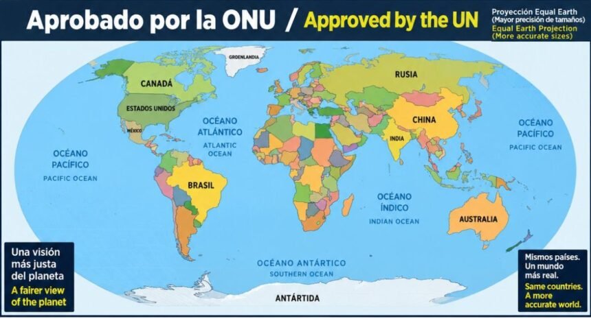
What Is the Equal Earth Map?
The UN resolution focuses on changing how the size of continents is visually represented on commonly used world maps. For centuries, the Mercator projection has been one of the most widely used map projections. However, it has long faced criticism because it significantly distorts the apparent size of countries and continents, particularly those located farther from the Equator.
One of the most frequently cited examples is Africa and Greenland. On a Mercator map, Greenland can appear comparable in size to Africa, even though Africa is roughly 14 times larger in actual land area.
The distortion happens because a spherical Earth has to be represented on a flat surface. The Mercator projection preserves directions and angles well, which made it particularly useful for navigation, but it does not accurately preserve the relative area of landmasses.
Why African Countries Want a Different World Map
The push for a different projection has been particularly strong among African countries.
The Equal Earth projection, introduced in 2018, was designed to represent the relative areas of continents more accurately while maintaining a recognisable shape.
In February 2026, the African Union’s 54 member states adopted the Equal Earth map, citing its ability to provide a more accurate representation of continents, especially Africa.
The proposal was later brought before the United Nations by Togo with support from African Union countries.
UN General Assembly Backs the Resolution
On Friday, the vote was passed by the UN General Assembly in favor of the resolution demanding an improved depiction of continents.
The resolution was supported by 164 nations. The United States cast its vote against the resolution, while six other nations abstained.
It does not change any national boundaries. It just changes the way in which landmasses are depicted on the map.
Foreign minister of Togo, Robert Dussey, claimed that changing the map wouldn’t change the physical reality of the world, but correcting a wrong picture will give us a true depiction of our world.
India and Africa Share Close Diplomatic Ties
India’s support for the African-led initiative comes against the backdrop of its broader diplomatic engagement with African countries.
New Delhi has consistently supported greater African representation in global institutions. India played an important role in the inclusion of the African Union in the G20 during its presidency of the grouping.
However, while supporting the principle behind the new map projection, India has drawn a clear line regarding the depiction of its own territory.